Discover the Bazaruto Archipelago
Mozambique’s Paradise islands awaits


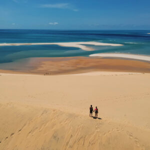
Bazaruto island tours from Vilanculos
A paradise for nature lovers
Whether you’re a scuba diver, snorkeler, or nature enthusiast, the Bazaruto Archipelago promises an unforgettable escape.
With five enchanting islands: Bangue, Magaruque, Benguerra, Bazaruto and Santa Carolina (Paradise Island); a day trip reveals azure waters and pristine sands.
Encounter playful dolphins and perhaps the elusive dugong. Flamingos grace shallow bay waters at low tide, while exquisite reefs offer superb snorkeling and scuba diving. Each tour includes a leisurely lunch break, ensuring you absorb the paradise vibes.
Pack your swimsuit and sense of adventure – the Bazaruto Archipelago awaits your exploration.


Traditional dhow tours
Experience the charm of sailing on a traditional dhow in Bazaruto
Set sail on the timeless dhows of the Indian Ocean, still used by Vilanculos fishermen. You can witness their picturesque ballet from Casa Babi’s rooms and garden. For a serene escape, opt for a dhow journey to Magaruque Island or a sunset cruise.
Enjoy a relaxing ride, accompanied by a friendly crew offering popcorn, tea, or coffee on board, while preparing your lunch right there. Lighting charcoal on a wooden boat may seem daunting, but it’s a practice they’ve mastered. Upon arrival, savor a delectable meal amidst island adventures or reef explorations. It’s a journey of simplicity, tradition, and natural wonders.


Bazaruto Archipelago National Park
Welcome to the Indian Ocean’s hidden gem
The Bazaruto Archipelago comprises 5 islands – Santa Carolina, Bazaruto, Benguerra, Magaruque, and Bangue – spanning over 1,430 km2. Renowned for its rich biodiversity, the area has been recognized as of global significance. It was declared a Protected Area in 1971 and became the first Marine National Park in Mozambique in 2001. One of the main objectives of the Park is to protect the region’s last viable population of dugong estimated at around 250 individuals.
Key highlights of the biodiversity in the area include
180 species of birds, 45 species of reptiles, 2000 species of fish, representing 75% of the species found in the Indian Ocean.
The Archipelago boasts diverse terrestrial and marine habitats, encompassing coastal sand dunes, rocky and sandy shores, coral reefs, mangrove forests, and seagrass meadows. One of the specificity of the landscapes are the massive tides that discover large beautifully white sand banks at low tide.